


VGN Elmore and Winding Gulf, WV track plan HO
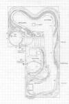
- Size: 19′ x 33′
- Scale: HO
- Minimum Radius: 30″
- Minimum Aisle Width: 30″
- Designed by Dan Bourque
 Elmore was the center of Virginian Railway operations in the coal fields. Mullens, just north (railroad west) of Elmore, was home to a major engine facility and the western terminus of electrification on the Virginian. Traffic through Elmore was predominantly coal, but there was meager non-coal traffic in the form of traffic to and from the NYC and C&O at Deepwater, WV. Because of the tipples included, this trackplan best fits the timeframe between 1940 and 1970. Prior to 1962, the mainline was electrified and the Virginian (N&W … Read more
 The St. Charles Branch was a tree-shaped branch of the Southern northwest of Appalachia, VA. The Southern owned the branch, but the L&N (and the CSX today) had trackage rights over the entire branch. It appears that a Southern mine run was operated out of St. Charles (two mine runs in the 70s) and served all of the mines up the branch lines. The coal would then be moved south through Pocket and over to the yard at Appalachia (later Andover), VA. …
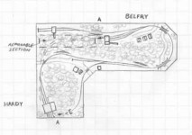
 The N&W’s Pocahontas Division was full of small branch lines serving numerous coal tipples. The Pond Creek Branch was one of the smaller of these branches and makes a great subject for a bedroom-sized layout.
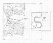
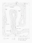
 St Paul, Virginia, was a unique piece of railroad. The N&W, travelling from East to West, and the Clinchfield, travelling from North to South, intersect and run parallel through the town with wyes at either end. The CRR and N&W interchanged at Boody, and there were a few small industries in town. St Paul offers a lot of variety in operation depending on the time period modeled. Up to the 60s, the N&W and CRR were the only game …
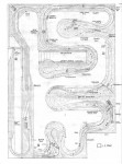
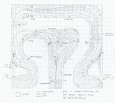
 Norton, VA was an important interchange point between three railroads: the L&N, the N&W, and the Interstate (Southern). The large yard was maintained by the N&W, but operated by both the N&W and L&N. Between two and four merchandise trains were exchanged daily between the two, while the rest of the traffic was coal. Until 1973, the L&N interchanged its Clinchfield-bound coal to the Interstate RR at Dorchester Jct (just west of Norton), and the Interstate hauled it to the Clinchfield at Miller Yard. Between 1973 …
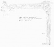
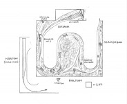
 Hagans Switchback is located on the L&N in between Loyall, KY and Appalachia, VA. The original Cumberland Valley Division mainline ran up the poor valley from Cumberland Gap to Appalachia. A major branchline was constructed to Loyall, KY and beyond soon after. With the goal of reaching the Clinchfield RR, the the L&N stretched the Martin’s Fork branch southward from Loyall through the 6,244 foot long Hagans Tunnel. The tunnel exits directly beneath the original CV main, but abruptly ends because of the lack of funds to complete the project. To …
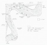
 Read more