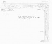


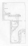
N&W Clinch Valley District, VA track plan HO
- Size: 19′ x 33′
- Scale: HO
- Minimum Radius: 30″
- Minimum Aisle Width: 30″
- Designed by Dan Bourque
 This track plan was designed to fit in a previous basement of mine. It models the west end of the N&W’s Clinch Valley District from Boody (St. Paul), VA to Norton, VA. In all, it represents about 20 miles of mainline and 2 miles of branchline. This was a very busy area with heavy minerun and interchange traffic. In all, there are four railroads represented on this layout: N&W, Interstate, Clinchfield, and L&N.
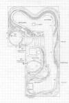
The Layout
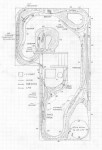
This layout includes most of the coal loaders along the line and … Read more
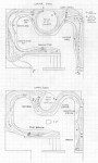
 Many railroads tangled in the Appalachians, but few areas featured as many railroads coming together as southwestern Virginia where the L&N, N&W, Interstate, Southern and Clinchfield all interchanged within a few miles.
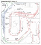
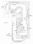
 Pemberton, WV was an important junction for both the Virginian (later the N&W) and the C&O. Pemberton lay in the middle of the Winding Gulf trackage for both railroads and was one of two interchange points in the area where both railroads crammed into the valleys (the other was Stone COal Jct. further south). Coal loaders surrounded both railroad’s lines in all directions.
 This track …
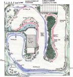
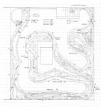
 The St. Charles Branch was a tree-shaped branch of the Southern northwest of Appalachia, VA. The Southern owned the branch, but the L&N (and the CSX today) had trackage rights over the entire branch. It appears that a Southern mine run was operated out of St. Charles (two mine runs in the 70s) and served all of the mines up the branch lines. The coal would then be moved south through Pocket and over to the yard at Appalachia (later Andover), VA. …