


- Size: 24′ x 40′
- Scale: HO
- Minimum Radius: 35″
- Minimum Aisle Width: 36″
- Designed by Dan Bourque
This track plan represents one of the most iconic pieces of railroad in the United States, the Southern Pacific’s Tehachapi Sub, home of the famous Tehachapi Loop. While certainly not an Appalachian track plan, it’s still a good study in prototype track plan design (and any mountain railroad is still pretty cool). This plan captures the key features of the line between Bakersfield and Mojave, CA circa 1990s when both the SP and ATSF (via trackage rights) ran 30-40 trains daily over this route.
The Layout
While 24′ x 40′ may seem like a lot of space for a layout, it was still a great challenge to fit so much railroad into this space. I designed this for a friend who has railfanned this area for years, so capturing some key scenes well was more important than capturing every scene or siding. Additionally, my tendency is to design Appalachian layouts with hills toward the backdrop and track/water in front. Cardinal direction is less important because the diffused light of hazy Appalachian days makes viewing from any angle possible. However, in the wide open western U.S., the sun is more prominent, and railfans and photographers tend to stick to the southern sides of the track. I learned from critiques of my early drafts (this represents the 5th design for this space) that the aisles needed to represent the southern side of the tracks so the scenes would be oriented as a railfan would see them on the prototype. That led to some compromises like a nod-under and some sub-optimal deck spacing in places, but capturing the key scenes more than offsets these compromises, in my opinion. It also has the benefit of always keeping an “right is east” orientation for operators.
The layout is a down-up-down design, but instead of two helixes, I used the natural grade of the route (1-2% in most places) to climb to the second deck from Algoso (just east of Bakersfield) to the Tehachapi Loop without a helix. The apex of the layout is the Tehachapi Loop, and from there, a helix takes the line back to the lower deck for the run from Tehachapi down to Mojave. The key scenes in rough priority order are 1) the Tehachapi Loop including the two crossings of Tehachapi Creek on the approach, 2) the horseshoe curves and tunnels at Cliff, 3) the large cement plant at Monolith, 4) the packing plants of Edison, 5) the yard and adjacent street scene at Mojave, 6) the S-curve and transition from orchards to mountains at Sandcut, and 7) the horseshoe curve at Caliente and cuts on the approach to Tunnel 1. Other considerations included wide radius curves (I chose 35″ as a good compromise) and long sidings (I chose 20′ as the minimum) to allow long trains to gently snake through the mountains.
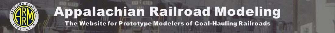
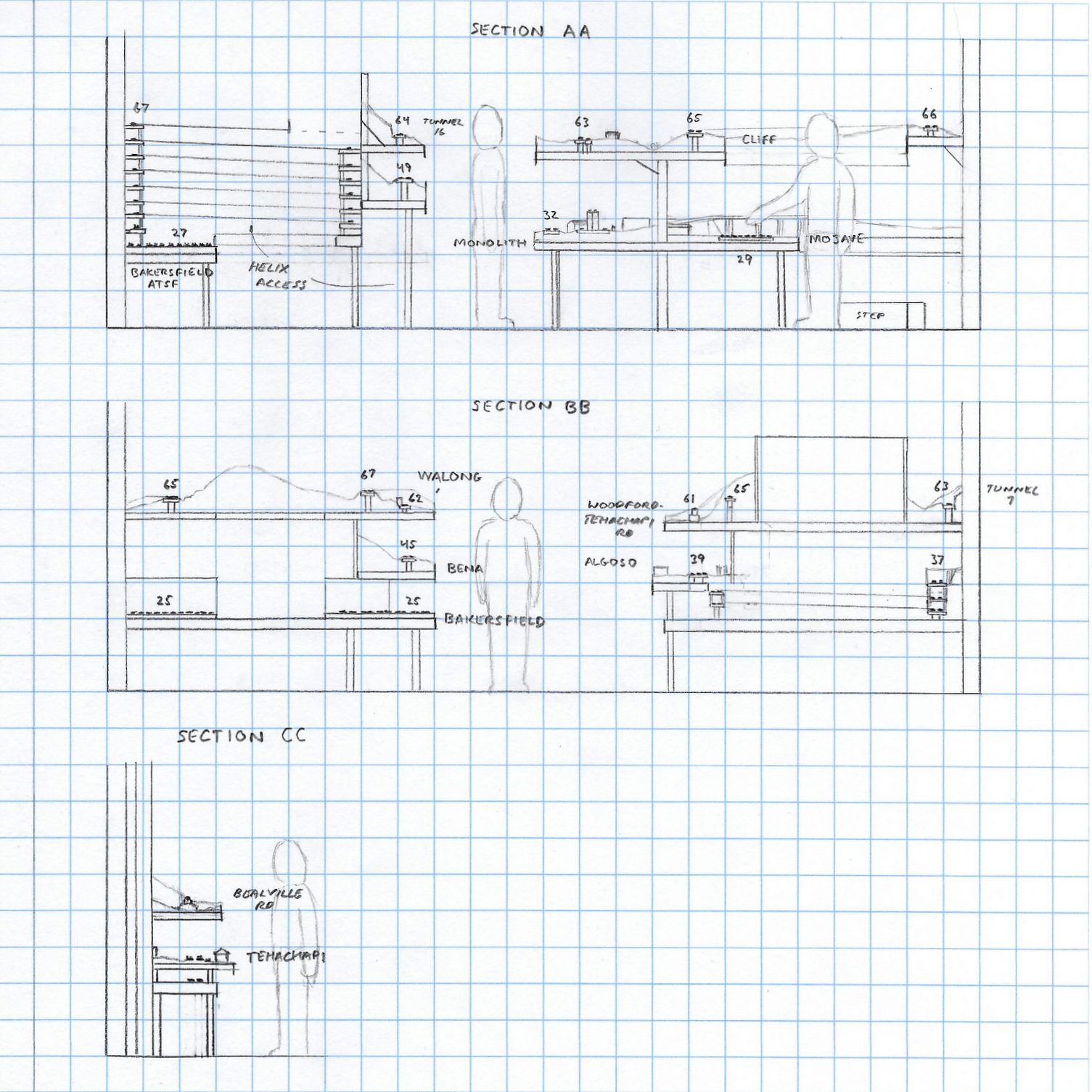
Lower Level
The lower level captures both ends of the line. On the west end is Algoso to Caliente. Algoso is an industrial area just at the edge of the farms and orchards between Bakersfield and the mountains. In the middle of the fields is Edison, home to more than a dozen packing plants on both sides of the double track main. East of Edison is Sandcut where the line makes a long S-curve to climb the eroded foothills of the Tehachapi Mountains. At Bena, the line goes to single track, but the entire line from Bena to the return of double track at Cable on the far side of the mountains is more passing siding than single track. The line from Ilmon to Caliente is compressed, but it captures key elements of the area to include crossings of Caliente Creek (dry wash), curves and cuts.
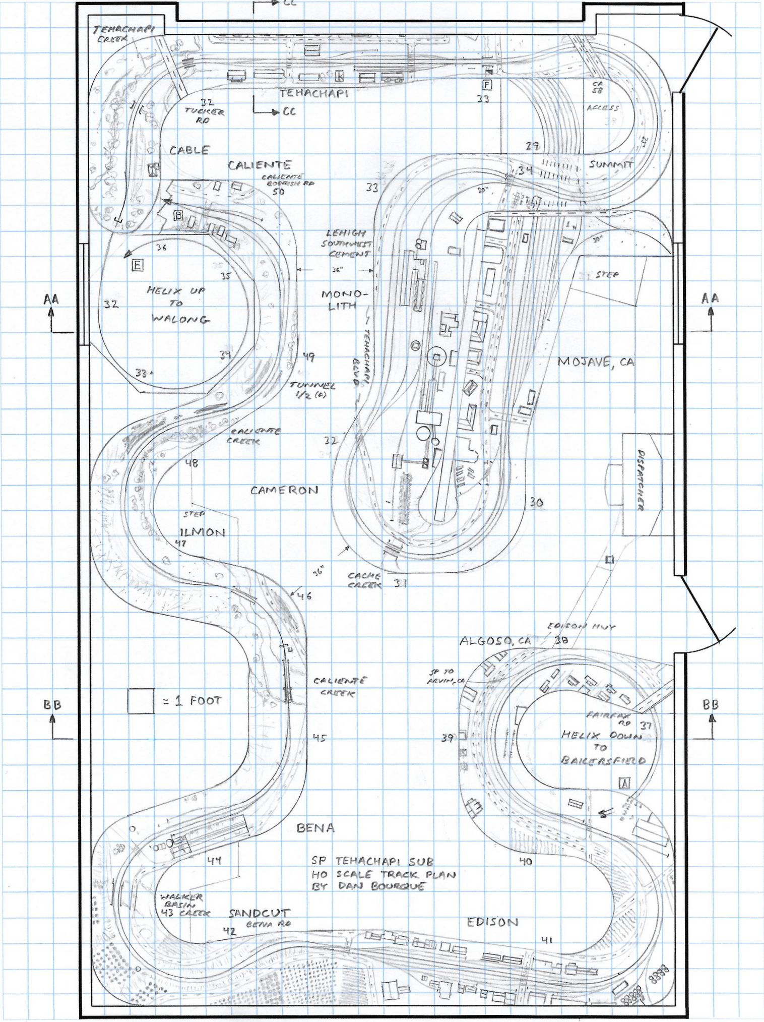
Caliente represents the transition from lower deck to upper deck and is home to a 180-degree horseshoe curve where the line crosses the creek and climbs up the other side of the valley across a bridge and along the hillside before reaching Tunnel 1. I used the space between Tunnel 1 and Tunnel 2 to climb a one-loop helix–this helps create additional distance between Caliente and Bealville, and it helps elevate the duck-under by about 5″. The upper peninsula represents the key scene from Bealville to Cliff where the line traverses two horseshoe curves and two tunnels. In real life, a railfan standing at Bealville can see trains to the west nearly to Caliente and can see trains accross the valley to the east climbing along the hillside at Cliff. This visibility is built into the layout by eliminating backdrops throughout this area.
Upper Level
From Cliff, the layout reaches the duck-under at a respectable 66″ track height making it more of a nod-under, and it can swing out of the way between sessions for easier access. At this point, the railroad was inaccessible to railfans until closer to Keene, but there were two tunnels. I’ve used them to hide the entrances and exits to a one-loop helix down. This helix absorbs some of the distance between Cliff and Keene, and it also serves to reset the track level for the climb up Tehachapi Loop–without it, either the duck-under would be too low or the loop too high. Keene consists of a horseshoe curve with the large buildings of the Chavez Center in the middle. The prototype is single track, but I had to extend the siding at Woodford westward into Keene to get sufficient siding length. Moving the siding westward also allowed the key scene of the loop to be modeled well, starting with the two bridges over Tehachapi Creek. The loop itself is the centerpiece of the layout. It’s situated next to a 6′ aisle with aisles on either side to allow 270 degree viewing. I used 38″ as the radius on the loop which scales it out to about half the prototype’s size–smaller than ideal, but respectable.
After the loop, the line dives into Tunnel 10 which begins the trip down the 7-turn helix. On the top loop, I added a neat scene capturing the tightly spaced Tunnels 15, 16 and 17 which can be seen on the hillside overlooking California Highway 58. The curves and distances measure out well, only the grade is opposite the prototype–still, it’s a neat scene and functionally makes the helix shorter with less hidden track.
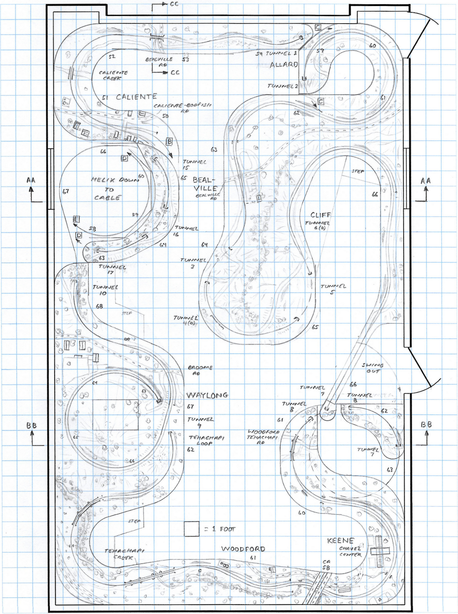
Back on the lower deck, the line pops out of a tunnel (in theory Tunnel 17, but that’s modeled at the top of the helix. . . a little compromise here) and into the siding at Cable before exiting the mountains into the straight double track through the town of Tehachapi. The top of the prototype grade is just east of Tehachapi at Summit. Rather than model Summit along the aisle, I chose to model it against the back wall six feet from the aisle. Practically, this allows more space to model Monolith, but it also creates a scene where a train can be watched trailing off or approaching from a distance. There are no switches here, so it’s pretty safe operationally. This leads to the massive scene at Monolith, home to a large cement plant. This area had to be tall because some of the buildings scale out to nearly 24″ tall. The final leg of the railroad between Monolith and Mojave is significantly compressed, skipping the scenes at Cameron and Warren. Mojave is actually a visible 8-track staging yard. I’ve moved an overpass from the east end of the yard and placed it over the middle of the yard to hide the transition into the backdrop.
Staging Level
Staging consists of three yards and 26 total tracks of at least 20 feet each, Mojave represents the SP’s east end, Bakersfield represents the SP’s west end, and a combination Bakersfield/Barstow yard represents the ends of the ATSF. There’s enough vertical space at Bakersfield to put a little scenery in, so I’ve added a few prototypical bridges, a portion of the engine facility (for visible storage of extra motive power), and the large SP station. A short double-track connection between Bakersfield and Mojave provides a continuous running connection and the ability to quickly shuttle trains between ends of the layout. Finally, there is a 32-foot long staging track adjacent to the ATSF yard to store one really long tank train (explained in the operations section).
Select Elevations
This layout, with it’s dozens of trains and several dozen locomotives, demands a high-end control system. A DCC system with wireless walk-around throttles would keep crews from tangling themselves, and it would probably require multiple boosters to power the large amount of track.
Operations
This layout would require several operators to come anywhere close to prototypical traffic levels. In the ’90s, this line saw about 30-40 trains per day, and it was CTC controlled, so a dispatcher would be mandatory (there’s space for a dispatcher’s desk near the duck-under). The continuous running nature of the track plan means a session could recycle trains as often as desired to get to the desired traffic level. Because Bakersfield and Mojave are staging yards, a yardmaster wouldn’t be necessary, though a hostler/yardmaster job could be added to shuttle the trains between staging yards and perhaps swap out some motive power at Bakersfield. Helpers could be run in one of two ways. At times, the SP ran helpers from Bakersfield to Mojave, so the helpers could simply be “MU’d” into the train via DCC for a single operator to run them. At other times, the SP ran helpers from Sandcut to Tehachapi/Summit, so 2-3 helper crews could be employed pushing trains up the grade and shuttling back to Sandcut light–the only trouble is helpers on the hidden track of the helix (sporty), so perhaps a modified run from Sandcut to Walong would be better. The Santa Fe ran its helpers from Bakersfield to Barstow.
Through freights would account for the vast majority of the traffic. Sidings of 20′ mean a train could be 3 engines up front, 2-3 helpers, and a generous 25-30 cars. A road crew job would consist of picking up a train in Bakersfield or Mojave and running it over the railroad from siding to siding per the dispatcher’s signals. Keeping eastbound uphill freights from Bakersfield to Mojave moving on the grade would be the priority with westbound downhill freights hopping from siding to siding. Of course, some uphill freights would have to wait in the sidings as well. One special freight is the Tank Train. The SP ran this extra long train over the Tehachapi Sub using three sets of power, hence the one extra long staging track. This train didn’t fit into most of the sidings in real life, so the fact it won’t fit into any of the model sidings is a prototypical headache the dispatcher will have to deal with. In addition to the freights, passenger trains also graced these lines, and along with a handful of priority fast freights, the dispatcher would need to keep these trains moving.
This line also hosted some locals to work the industries along the right-of-way. At least one local would be needed to work the west end of the line from Bakersfield to Bena (and occasionally Caliente, Bealville, and Woodford), especially during growing season when the packing houses would be busiest. Another local would be needed to work the east end from Mojave to Tehachapi with the primary customer being the Lehigh Southwest Cement Company at Monolith. If you wanted to give up a staging track or two, Mojave could also be used to classify and add interchange traffic from both the Trona railway and the SP’s line to Cal Portland Cement (via the wye at Mojave).
Additional variety could be added by changing eras anywhere from the 1970s to the 2000s. Scenery and operations would remain essentially the same, but motive power and cars would be changed out to represent the times, to include replacing the SP and ATSF power with UP and BNSF. This layout offers not only a lot of great operation, but it gives the builder a chance to model some really great scenes on one of the best known pieces of railroad in America.
Things I Like About this Plan:
- Several really great scenes to model
- Railfan perspective, especially on upper deck
- “Right is east” orientation throughout
- Generous track radius and aisles
- Long trains
- Mostly visible staging
- Continuous running (unlimited trains)
Things I Don’t Like About this Plan:
- Long helix
- Nod-under
- Some grades are not prototypical (like downgrade eastbound through Tunnels 15-17)
- Some scenes on lower deck compressed vertically
Related Products
Depending on the era, any modeler could have a real variety of motive power. In the mid-80’s, you could see the “Kodachrome” SP red and yellow along with the “SF” in blue and yellow for the proposed but never approved SP-SF merger. Some wags reported that these initials could mean “Shouldn’t Paint So Fast”!
I saw the Loop in person a few times between 1991-93 and was impressed with indeed the variety and frequency of trains. SP used SD-45’s almost exclusively with a few GE’s making their ways as time went on. I think some were B39-8’s; at any rate they were 4-axle units. Some of them powered the TankTrain, IIRC.
Modeling the TRONA line would give a reason to dust off some of the (Stewart?) Baldwin AS-616’s from yesteryear. Trains Magazine had an article about the Trona published somewhere between 1988-1990.
A few comments about scenery. 1, On the Mojave side, part of the land was table top flat until you headed kinda north towards Tehachapi itself. Then the fun of climbing the mountains began all the way to Bakersfield! The first time we drove to Bakersfield I was amazed at the lush, green orchards on the north side of the mountains compared to the desert like conditions south. 2, don’t forget the zillions of wind turbines to the west, dotting the mountains like overgrown dandelions! This again was the 1991-93 time frame. 3, Mojave had the former SP depot (I think it was), painted a light green color, as late as 1992 or so. No idea what it was used for and I don’t recall its ultimate history; 4, closer to Barstow, perhaps, but definitely in the Edwards AFB area, don’t forget to add some “Joshua” trees–some of the most unusual vegetation in the world. These don’t grow in Appalachia!
Passenger service was almost gone by the early 90’s, if not sooner–I think Amtrak took passengers along the coast instead of through the mountains, but you could always claim a detour! And, also during 1991, Santa Fe’s 3751 ran steam excursions from Barstow (I think) to Bakersfield, with Santa Fe tracks meeting SP’s in Mojave,
There were a couple of other things I didn’t mention in my previous post. Referencing the “Trains” magazine article, SP had a local between Mojave and Palmdale called the “Blitz” local. One photo showed an SD-45 and caboose but after the no-caboose period it was just the engine. I don’t remember which industries or customers were serviced by that train.
If at all possible, don’t forget to model a certain fast food restaurant in Mojave! Train crews would sometimes hike (run!) across the highway (Cal 58, IINM) to grab a Mac-tastic meal before heading back to the train.
I know it would be nearly impossible to add but Rosamond would be a nice touch to model. The line to Palmdale and LA was single track through there and had a bit of a downhill grade going south. When the train was about to cross the main highway, the traffic lights would begin to flash yellow until the train went by. Another “tasty” scene is the “Little Red’s” Donut Shop, literally by the tracks. I was in there one time when a train came by and the vibrations nearly shook the coffee out of my cup!
Ideas for what kinds of trains to model are easy to find. If you can snag episodes of “Trains and Locomotives” on RFD-TV, they’ve had I don’t know how many programs dedicated, at least in part, to the Loop. One of my personal favorites was a military train heading northbound, hauling tanks!
All in all, a very good design. Dan, keep up the good work!
Here’s a link to a photo near Mojave taken sometime in 1991-92 time frame, Trains were still SP or SF in those days.
Link: http://www.rrpicturearchives.net/showPicture.aspx?id=4828865