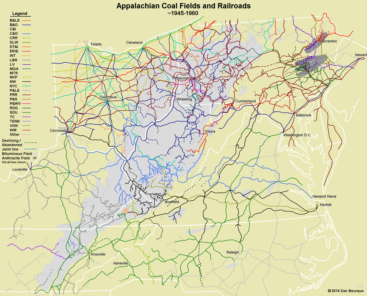
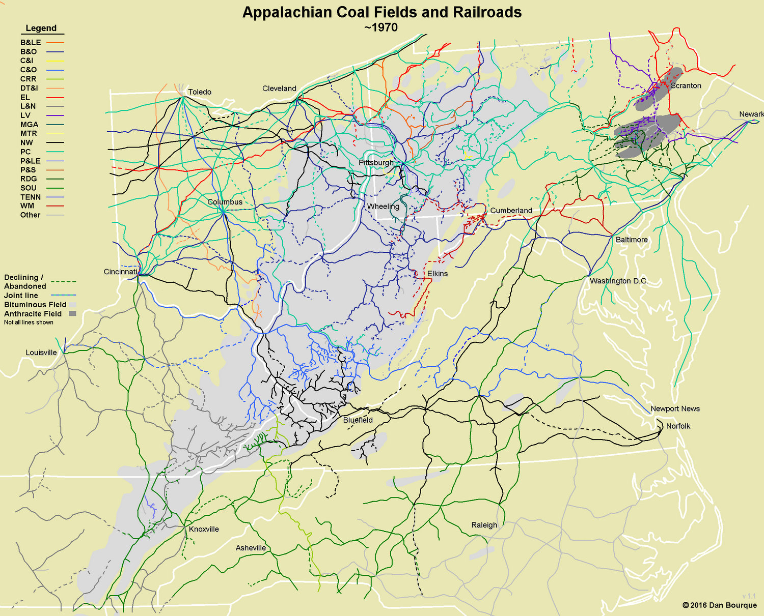
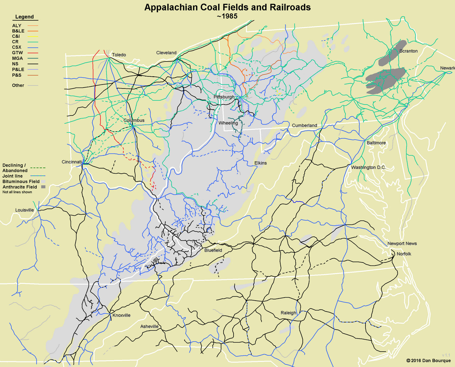
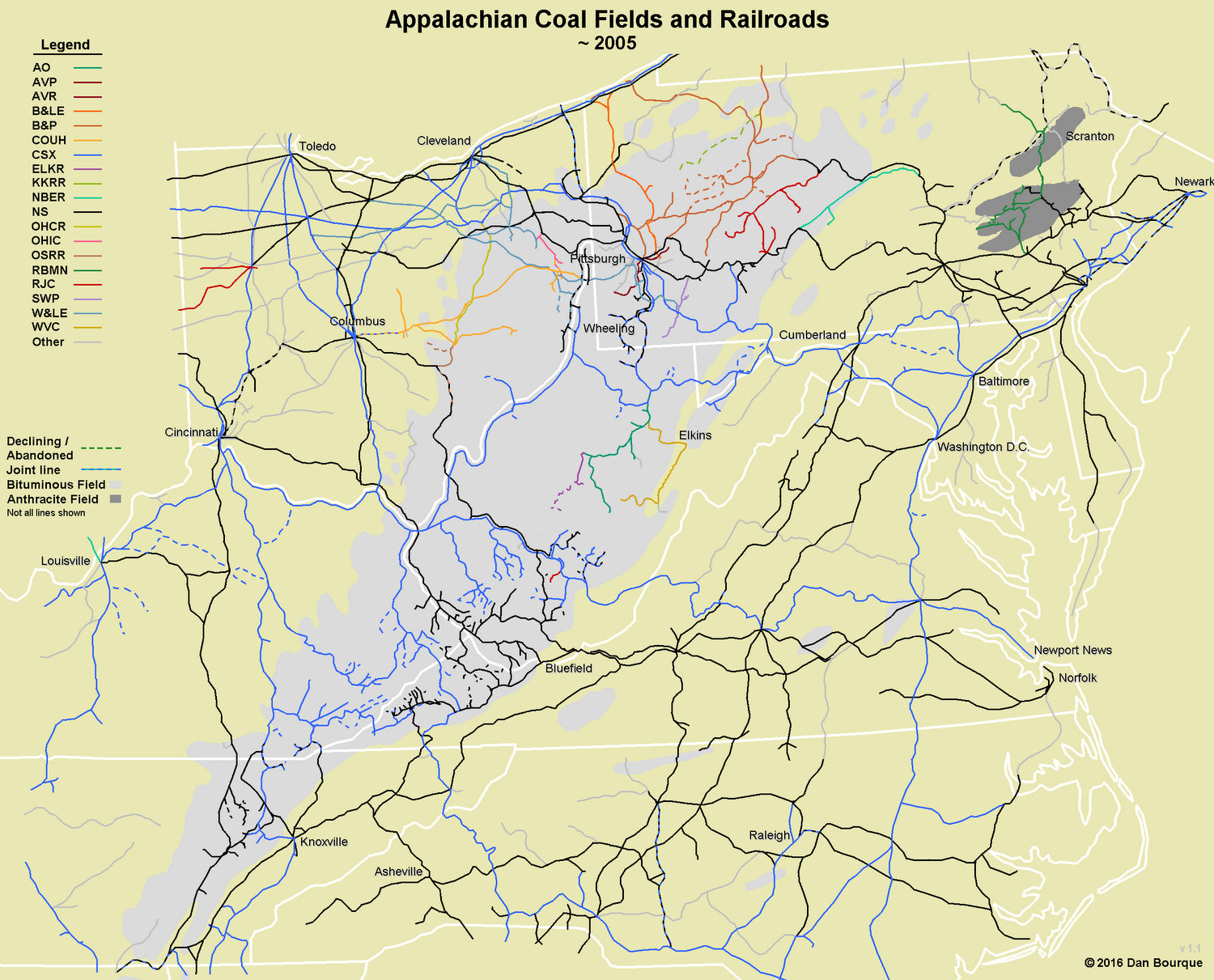
The evolution of coal-hauling railroads in the Appalachians is fascinating, especially over the last 60 years. Six years ago, Appalachian Railroad Modeling published its first map of the coal fields and railroads circa 1950. While it was informative, these four maps go well beyond the original to show how Appalachian railroading changed over time, and together they tell a fascinating story of growth, downsizing, consolidating and rebirth. Based on the resources I had, it was difficult to tell when certain lines were abandoned, especially in the 1945 and 1970 maps, so many of the dashed lines in the 1945 map may have been active, and many of the dashed lines in the 1970 map may have been abandoned decades before. I learned a lot in creating these maps, and I hope you enjoy them and learn something, too!
1945-1960
The first map (~1945-1960) represents the Appalachian railroads at their height when coal production reached its max during WWII. This was the peak of the 20th century Class I railroads who had laid rails into seemingly every nook and cranny of the Appalachians. During this era, each of the major railroads had its slice of the coal fields. Starting at the northeast corner of the Appalachian coal fields, the Pennsylvania (PRR) and New York Central (NYC) intertwined with the Baltimore and Ohio (B&O) to reach some of the earliest developed coal near the rivers and steel mills of western Pennsylvania and eastern Ohio. Mixed among the big players were regional players like the Bessemer and Lake Erie (B&LE), Pittsburgh and Lake Erie (P&LE), Pittsburgh & West Virginia (P&WV) and Nickel Plate Road (NKP) and a host of coal-hauling short lines such as the Pittsburg and Shawmut (P&S), Cambria and Indiana (C&I), the Montour (MTR) and the Monongahela (MGA). Moving into West Virgina, the B&O owned a large portion of the rails in the north and central portions of the state ceding only the easternmost sliver to the Western Maryland (WM). The Kanawha River represented a clear transition of influence from the B&O to the Chesapeake and Ohio (C&O), though the NYC moved in from Ohio to invade the fields just north of the Kanawha. The C&O split the southeastern portion of WV with the Virginian (VGN), and the Norfolk and Western (N&W) owned the rails and branches along the very southernmost portion of WV and adjacent fields in VA. Southwestern Virginia was divided between the N&W, the Clinchfield (CRR), the Interstate (INT) and the Southern (SOU). Just over the ridge in Kentucky, fields were split between the C&O and the Louisville and Nashville (L&N) with some incursions from the Southern and N&W. The southwestern tip of the Appalachian coal fields reached into Tennessee where the L&N and Southern wrestled for control alongside a few short lines like the Tennessee Railroad (TENN) and the Tennessee Central (TC).
During this era, coal fields were dominated by tipples both large and small. Most loaded numerous sizes of coal over multiple tracks, and most tipples were directly connected to the mines they served. This meant railroads had to bring the tracks close to the coal, leading to the “rails in every holler” that can be seen on this map. To work these hollers, mine runs crawled up out of nearly every yard in the coal field with more than three tracks, and strings of hoppers were marshalled into long coal drags to take the coal to industrial centers, piers and hundreds of smaller dealers taking one carload of coal at a time. By 1960, though, many rails had already been abandoned, particularly in the northern portion of the Appalachian coal fields where some of the earliest rails had been laid.
1970s
The second map represents 1970. The most significant change is in the northern portion of the coal fields where the economically troubled PRR and NYC combined to form the economically troubled Penn Central (PC). North of the PC, the Erie Railroad and the Lackwanna, two major players in the anthracite coal fields of eastern PA, also merged to become the Erie Lackwanna (EL). Additionally, by 1970 many of the regional players had been absorbed into larger roads, particularly the N&W which now owned the NKP, P&WV and Virginian.
By 1970, the coal tipple was on the decline, and a new type of loader, the flood loader, began taking its place. The decline of the tipple and rise of the flood loader corresponded with a major change in both customers and mining techniques. Shaft mining operations were being replaced with strip mines using conveyors or trucks to bring larger amounts of coal to the newer, faster loaders. Also, with a decline in residential coal use, customers requiring varying grades of coal were shrinking while coal-fired power plants requiring an endless stream of black diamonds were on the rise. To feed these power plants, railroads added unit trains alongside the mine runs. The unit trains were dedicated to moving coal from one loader (typically a flood loader) to one customer (typically a power plant). Another trend of the 1970s was the increase in popularity of the small truck-dump loader. In the early ’70s, the energy crisis over oil led to a coal boom, and mom-and-pop mining operations sprang up right and left to load hoppers with coal trucked in from nearby mines. Because the coal was trucked in, truck dumps tended to spring up along existing rails and yards instead of driving new ones. Most truck-dumped coal was “raw coal,” so rather than being shipped directly to a customer, much of it was shipped to an intermediate preparation plant (prep plant) to be cleaned, sorted and combined before moving to its final destination.
The ’70s were also marked by increased cooperation between many of the remaining Class 1s in the region. While coal was still predominantly hauled by rail, this was not the story in many other sectors of industry where rails and freight cars were being increasingly replaced by highways and trucks. Cooperation helped railroads remain competitive by streamlining operations and rates along a broader and more streamlined route. The most recognized of these cooperative identities was the Chessie System, a cooperative effort between the B&O, C&O and WM. To the south, the L&N, Clinchfield, Seaboard Coast Line and others formed the Family Lines. To further increase their economic standing, these roads continued to abandon less productive lines in the coal fields and elsewhere.
1985
The third map represents 1985, and the changes of the last 15 years are clearly evident. The region surrounding the coal fields was now dominated by three new super-railroads. In the north was Conrail (CR), the government run railroad formed from several failing railroads including the PC, EL, Lehigh Valley (LV) and Reading (RDG). The middle section of the coal fields was dominated by CSX, formed by merging the railroads of both the Chessie System and Seaboard System (the result of the official merger of the Family Lines cooperative roads). The third super-railroad was the Norfolk Southern (NS), formed from the relatively healthy Southern Railway and NW.
By 1985, the very last of the WWII-era tipples were in their final years of operation, and with the decline of the coal boom, even truck dump operations were being abandoned or operating sporadically. Unit trains and flood loaders began to dominate the scene, mostly paired with enormous strip mines. With the combination of railroads also came the inevitable elimination of redundant trackage, especially for Conrail, though all the railroads took part.
2005
The last map represents 2005, and its story is perhaps the most interesting. Only one of the railroads listed in the 1945 section retains its original identity, the B&LE and its corporate partner, the Union RR (not identified on these maps), though by 2005 the B&LE is owned by the Canadian National. The most notable absence is Conrail, now carved up between CSX and NS. Despite the demise of Conrail, the number of railroads in the region actually begins to rise. As CSX and NS looked to streamline their operations, they sold many of their lines to new short lines or regional railroads who can serve the remaining customers more economically.
Pennsylvania shows the most change with new regionals like the Buffalo and Pittsburgh (B&P) and RJ Corman (RJC) Pennsylvania Lines, and Nittany and Bald Eagle (NBER) occupying many of the former Conrail lines in the coal fields. The Reading, Blue Mountain and Northern (RBMN) took over much of the former lines in the anthracite region of PA. Railroads like the Allegheny Valley (AVR) and Southwestern Pennsylvania (SWP) serve the few remaining non-coal customers on former B&O and PRR coal branches. Gone are the Montour and C&I, and the Monongahela and P&LE lines have been absorbed into NS and CSX. Ohio has also seen the spin-off of much of its railroad lines to short lines and regionals including the Wheeling and Lake Erie (W&LE), Ohio Central (OHCR), Ohio Rail (OHIC), and the Columbus and Ohio River (CUOH). Much of the former B&O and WM in West Virgina has been released by CSX and is now run by railroads like the Appalachian and Ohio (A&O), Elk River Railroad (ELKR) and West Virginia Central (WVC) which runs tourist trains pulled by shays and former WM first generation diesels. These new railroads add new color and character to the rail lines of the Appalachians, and they replace 21st century locomotives with the cast-offs from the Class 1s, bringing new life to old rails and locomotives.
Disclaimer: While I spent dozens of hours researching and drawing each map, I’m sure there are still a few errors. If you see one, please contact me or leave a reply to help make this project more accurate.
Related Products:


Pingback: Adapting to Change: Railroad Routes Turning into Recreation Trails – expatalachians
I was browsing through the maps and I wondered what railroad company had the ROW through my hometown of Spartansburg, PA and the PRR section near Corry heading southbound gave me a answer to what plans for my research for creating a model railroad of a “fallen flag”.
Hello, that was the Pennsylvania, running out of Oil city area , it connected up with the NKP at Brockton Ny. Much of the row is now hiking trails.