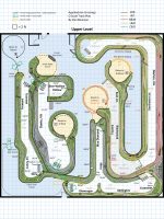
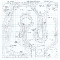
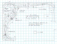
NC&StL Pikeville Branch, TN track plan HO

NCSTL Pikeville Branch TN HO scale track plan
  • Size: 12′ x 12′
  • Scale: HO
  • Minimum Radius: 24″ 
  • Minimum Aisle Width: 30″ 
  • Designed by Dan Bourque

This track plan was a personal challenge to see whether a double-deck plan for a long branch line could be modeled in HO scale in a tight space of less than 12 x 12 feet. The subject is an area I hadn’t known much about before. I discovered it on an L&N coal mine map from 1966, and thanks to the great site historicaerials.com, I was able to explore topo maps and aerial photos from the late 1950s about a year after the branch transitioned from the Nashville, Chattanooga, and St. Louis (NC&StL) Railroad to the Louisville & Nashville. What I … Read more

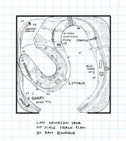
LN Davidson Spur, KY track plan HO

L&N Davidson Spur HO scale track plan
  • Size: 12′ x 12′
  • Scale: HO
  • Minimum Radius: 28″ 
  • Minimum Aisle Width: 21″ (mostly >36″)
  • Designed by Dan Bourque

L&N Logo(Note: this track plan and description have been updated twice to include additional details provided since the first posting–thanks to coal-field guru Robby Vaughn for clearing things up!)

The Louisville & Nashville had more coal branches than you could shake a stick at, and they came in many sizes. One of the smaller branches was the Davidson Spur which left the Eastern Kentucky (EK) mainline at Lothair, KY. After crossing the North Fork of the Kentucky River, the branch … Read more

C&O E&BV Sub, KY track plan HO

C&O E&BV Sub HO scale track plan by Dan Bourque
  • Size: 27′ x 30′
  • Scale: HO
  • Minimum Radius: 30″
  • Minimum Aisle Width: 30″
  • Designed by Dan Bourque

C&O LogoThe C&O was the king of coal hauling in the Appalachians, and some of the largest operations it served were in eastern Kentucky on the Big Sandy Subdivision. One of the coolest parts of the Big Sandy was the area geographically south of Martin, KY including the Long Fork Sub and Elkhorn & Beaver Valley (E&BV) which followed the left and right forks of Beaver Creek, respectively. The Long Fork Sub was densely packed with loaders of all shapes and sizes … Read more

SOU St. Charles Branch, VA track plan HO

SOU St Charles Branch, VA track plan HO
    • Size: 12′ x 16′
    • Scale: HO
    • Minimum Radius: 24″ 
    • Minimum Aisle Width: 30″
    • Designed by Dan Bourque

Southern LogoThe St. Charles Branch was the Southern Railway’s primary coal branch in Virginia until the acquisition of the Interstate Railroad in 1960. The St. Charles Branch ran from the Southern’s yard at Appalachia, VA for several miles until joining with the L&N at Pocket, VA and heading up Straight Creek to the small yard and wye at St. Charles and several tipples that lined branches north of town. Like many of the Southern’s coal branches in the corner of VA/TN/KY, the line was shared … Read more

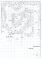
L&N Eastern Kentucky Coal Fields, KY track plan HO

L&N EK Coal Fields, KY HO scale track plan

ARRM’s 100th track plan and first place winner for the 100th Track Plan Contest is Donald Dunn.

Donald’s idea is to model the L&N’s Eastern Kentucky (EK) Sub coal fields including Hazard, Dent, the Carrs Fork Branch, Leatherwood Branch and Rockhouse Creek Branch in the 1970s. Donald grew up in this area and later worked for the CSX out of Hazard–he’s always wanted to model this area. I loved the challenge of fitting a lot of branch lines and tipples into this space.

  • Size: 25′ x 25′
  • Scale: HO
  • Minimum Radius: 29″ mainline, 27″ branch line
  • Minimum Aisle Width: 30″
  • Designed … Read more

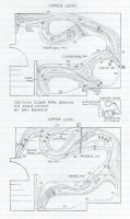
SOU L&N Clear Fork Branch track plan HO

SOU L&N Clear Fork Branch track plan HO
  • Size: 12′ x 16 ′
  • Scale: HO
  • Minimum Radius: 24″ 
  • Minimum Aisle Width: 30″
  • Designed by Dan Bourque

Southern LogoThe Clear Fork Branch on the border of Tennessee and Kentucky branched from the L&N’s mainline but was owned by the Southern Railway and jointly served by both roads. The Southern reached it via trackage rights from a connection to it’s Jellico line a couple miles north of the branch. The branch was several miles long, but most of the loaders were stacked in the last half of the branch between Clairfield, TN and Fonde, KY.

The Layout

This track plan captures the Clear Fork Branch from Clairfield to … Read more

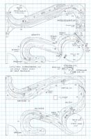
L&N SOU Middlesboro, KY track plan HO

L&N SOU Middlesboro, KY track phan HO
  • Size: 15′ x 20′
  • Scale: HO
  • Minimum Radius: 30″ (unless otherwise noted)
  • Minimum Aisle Width: 30″
  • Designed by Dan Bourque

L&N LogoThe L&N first reached the hamlet of Middlesboro, KY (then Middlesborough) around 1890 on it’s quest to tap the coalfields and build a bridge route to the Norfolk & Western in western Virginia. From Middlesboro, the L&N used (and later acquired) the Southern’s (KCG&L) tunnel near the Kentucky/Tennessee state line at Cumberland Gap to reach Tennessee and then Virginia. For a few decades, this route formed the mainline of the L&N’s Cumberland Valley (CV) Division. The Middlesborough … Read more

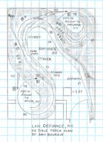
L&N Defiance, KY track plan HO

L&N Defiance, KY track plan HO scale
  • Size: 11′ x 14′
  • Scale: HO
  • Minimum Radius: 27″ 
  • Minimum Aisle Width: 35″
  • Designed by Dan Bourque

L&N LogoThe L&N’s Eastern Kentucky (EK) Division ran through the eastern Kentucky coal fields. It consisted of a long line between the L&N mainline and the heart of the EK at Hazard, Kentucky. From Hazard, lines went up a number of streams and hollers including the Carr Fork of the Kentucky River. The Carr Fork Branch served more than a dozen tipples in the several miles between Jeff, KY and Anco, KY. Defiance, KY was about halfway up the Carr Fork Branch. A … Read more

SOU Monarch Branch, VA track plan HO

SOU Monarch Branch, VA HO scale track plan
  • Size: 15′ x 20′
  • Scale: HO
  • Minimum Radius: 27″ 
  • Minimum Aisle Width: N/A
  • Designed by Dan Bourque

Southern LogoThe Southern Railway’s branch to Monarch, VA was a leg of the coal-producing St. Charles Branch west of Appalachia, VA. The L&N had (and CSX still has) trackage rights on the branch, so mine runs from both railroads worked the major mines on the line including Blue Diamond’s Monarch Mine, Benedict and Kemmerer Gem.

The Layout

L&N LogoThis track plan represents the Monarch Branch and Kemmerer Branch of the St. Charles line as … Read more

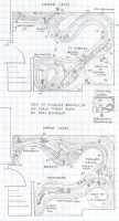
SOU St Charles Branch, VA bedroom track plan HO

Southern St Charles Branch track plan HO scale by Dan Bourque
  • Size: 13′ x 14′
  • Scale: HO
  • Minimum Radius: 24″
  • Minimum Aisle Width: 33″
  • Designed by Dan Bourque

Southern LogoThe St Charles branch can be found in extreme southwestern Virginia. A neighbor of the Interstate Railroad, the lines of this branch extended from the Southern’s yard at Appalachia, Virginia, down the Powell River, and then fingered out along several creeks up toward the Kentucky border. Like many other Southern Railway coal lines, it was jointly operated with the L&N who had trackage rights on the St Charles branch from its connection at Pocket, VA. Traffic and tipples ebbed and flowed over the years, but CSX and NS unit trains continue … Read more